Near the village of Czarnocin, on the road to the village of Wólka, there is a small boulder. It shows an indentation resembling the trace of an animal's paw. Associated with it is a legend about a huge lizard that once ravaged the area. According to it, one day a mysterious woman came to the village of Czarnocin, leaned over the stone and put something on it. She ordered the villagers not to step on the stone from now on. At nightfall, the lizard came out of the forest and dashed toward the people waiting by the stone. As soon as it stepped on it, it immediately began to shrink in size and size until it disappeared completely. Only the trace of the monster's paw remained in the stone. A smaller depression is supposed to be the imprint of the paw of a dog that stood on the boulder and also disappeared.
Dimensions of the stone: 70 × 50 × 30 cm. Natural indentations are visible on the surface.
Sources of information: Gierala 2013; field queries
An erratic boulder (rapacious granite) with a circumference of 11 m and a height of 1.25 m. Called "Devil's Stone" or "Sacrificial Stone of the Prussians". The surface shows furrows and depressions that are traces of attempts to break the boulder. Local legend says that in the clearing where the boulder lies after sunset the ethereal figure of the White Lady appeared. One of the innkeepers, returning from the inn on St. John's Eve, took a shortcut near the boulder. A white figure appeared to him and entreated him to dance. They twirled to a well near the first buildings of the High Village. The white lady grabbed the man and flicked him around the well, then let him go and disappeared.
Sources of information: Czernicka-Chodkowska 1980, 44; Radziwiłowicz, Szczepkowski 1967, 67; Grążawski 2010; information board placed at the boulder; field queries
According to local legend, the village of Wegielsztyn was to be located on the site of a sacred grove of Prussians. An angel (standing or sitting) appeared to the woodcutters on a stone lying in the place of today's church and ordered them to establish a village here. According to another version of the legend, the village was to be moved to this place by the angel's order. A trace of his hand was imprinted in the boulder. The name of the village is said to be derived from the German "Engelstein" - "angel stone". The church contains a late medieval stone baptismal font, which, once placed in front of the temple, attracted crowds of believers. It was believed that the rain water collecting in it had miraculous healing powers. According to one version of the legend, it was made of "angel stone."
Information sources: Lapo 2010, 137-138; Lapo 2014
An erratic boulder (gray granite-gneiss) with a circumference of about 15 meters, length of 5 meters, width of 4 meters and height of 2.2 meters lying in the waters of the Vistula Lagoon, northeast of the town of Tolkmicko. There is a small depression in the upper part of the boulder, and cracks and weathering are visible on the surface.
The boulder is known as the "Holy Stone." According to a number of accounts dating back to the 16th century, it was supposed to be dedicated to the Prussian god Kurke. He enjoyed a special cult among fishermen. On the boulder "firstlings", i.e. the first fish caught, flowers, food, were placed and burned as offerings.
One legend written down in the 19th century says that the stone fell into the waters of the Vistula Lagoon as a result of a fight between giants. Another legend treats of two brothers, one very strong and violent, the other weaker. The stronger brother, in anger, threw a huge boulder at the other, which fell into the waters of the Vistula Lagoon. The boulder is visible from the shore, where a vantage point has been established. It is impossible to reach it directly.
An erratic boulder with a circumference of 12.5 meters and a height of 2.2 meters, known as "Klickstein", i.e. "Clicking Stone" or "Devil's Stone". It is located in the central part of the hill, at a distance of about 1 km from the buildings of the village of Rościn. Around it are a number of other smaller boulders forming a circle about 15-20 m in diameter. A Bronze Age burial cemetery was discovered at the site. Before World War II, the surroundings of the boulder were landscaped, surrounded by a stone wall with benches set up. This is the only lithophone known from the area of today's Polish lands. Originally the boulder consisted of two parts - the upper one, movable when moved, hit the base making a characteristic sound. After World War II it was taken away and used as a boulder-monument, marking the 15th meridian in the nearby village of Trzcinna, Nowogródek Pomorski commune, Myśliborski district.
Sources of information: Glabinski (ed.) 2009, 89-90; Gruszczyńska-Ziółkowska 2018, 121; information board set up at the boulder; field queries
Geographic coordinates: 52.8896, 14.7760 (top of stone: 52.891187, 14.997966)
The so-called "Boulder of Triglav" or "Devil's Stone", now located in the parish cemetery. Its perimeter is 44 m, height 3.8 m, length 13.7 m on the N-S line. The erratic boulder belongs to the category of oligoclase-andesite paragneiss with garnets. It is the largest erratic boulder in the Polish lands and one of the largest glacial boulders in the European Lowlands. The surface shows cracks, glacial outcrops, a cross and a plaque.
Two legends are associated with the boulder. According to the first, it was dropped in this place by a devil called Smetek. A long time ago, the owner of the surrounding estate wanted to build a church. He summoned a mason and ordered him to erect a temple in a very short time. The mason found himself in a predicament, knowing that he would not have time to build, but then a powerfully built man stood by him, who said that he was also a mason and would help with the task. He would build the church himself within the timeframe given by the heir. However, he made a condition that upon completion of the work, the mason would give him his soul. The mason noticed that the interlocutor was the devil himself and also made a condition - the church was to be ready the next day by the first crowing of the rooster. The agreement was signed in blood. The devil got to work and quickly began to erect the temple. The mason was frightened that he would lose a bet with the devil and decided to resort to a forté. Before the devil finished the building, he entered the pigsty with a lantern, so that the rooster began to crow thinking it was sunlight. The devil realized that he was losing, felt sorry for the work he had put in and decided to destroy the temple. He grabbed a huge boulder with his huge talons, but missed. The stone fell next to where it is now. The cracks visible on its surface are supposed to be the marks of the devil's claws.
According to the second legend, a pagan temple dedicated to Triglav was located at the site until the 12th century. A stone statue of the deity was supposed to stand next to it and a mighty oak tree grew. The local population was supposed to be converted by a missionary who performed miracles. He miraculously caught huge amounts of fish, and also healed the sick. This convinced the local population of the truthfulness of the new faith, after which they themselves toppled the statue of Triglav and demolished his temple. A cross was placed on the boulder.
Sources of information: Czernicka-Chodkowska 1977, 27; Czernicka-Chodkowska 1980, 30-32; Lysiak 1998, 30-31; field queries
Two flat erratic boulders can be seen in front of the entrance to St. Peter and Paul Church in Smogolice. According to local legend, centuries ago the roofs of houses broke off, animals got sick, and people in Smogolice were gripped by fear. Even the village's church did not escape these unusual phenomena - the roof crackled and the stained glass windows splintered. People were terrified and did not know what to do. The village leader named Sebastian, called a meeting of peasants to find a solution together. During the meeting old Adalbert proposed to subdue the devil, who was responsible for the misfortunes. It was decided to set nets in the attic of the church, where the devil most often appeared. After several nights, the devil was caught, and when he was sprinkled with holy water, he shrank and shrunk. He was dragged out of the temple and thrown into the dungeon, located next to the church door. The entrance to the dungeon was covered with stones, and two large flat boulders were placed on top, so that people could trample on the devil as they walked to the church. After this event, the situation in the village normalized, and misfortunes subsided. The sick recovered, animals stopped getting sick, and the village became peaceful. To this day, in front of the entrance to the church, you can see two flat stones that symbolize the coping of the villagers with the devil.
According to the description of A. Pleszczyński (1888), a stone measuring 240 cm long, 120 cm wide, 60 cm high was said to lie near the so-called old guest road. Shaped like a rectangle, with a flat surface, on it a round bowl-shaped forging, according to the author "outlines convexly as if the shape of a shield". The boulder removed (it was caved in at about 60 cm), numerous fragments of earthenware were discovered around it.
The boulder was dug up by local peasants "who were looking for treasures under it."
No further information on the beliefs or customs associated with the stone has been recorded.
In the Sokule forestry area near Biała Podlaska, "among the bushes and shrubs" there was said to be a huge stone having a trough-like depression in the center.
Today the stone does not exist, it is possible that it lay in a swamp bearing the name "Stone", probably destroyed during forest plowing. The swamp bears traces of numerous digging with a backhoe and plowing with a deep plow.
According to local beliefs, the water collecting in the pit was said to have healing properties.
A field search yielded negative results, and currently no memory of the boulder has survived.
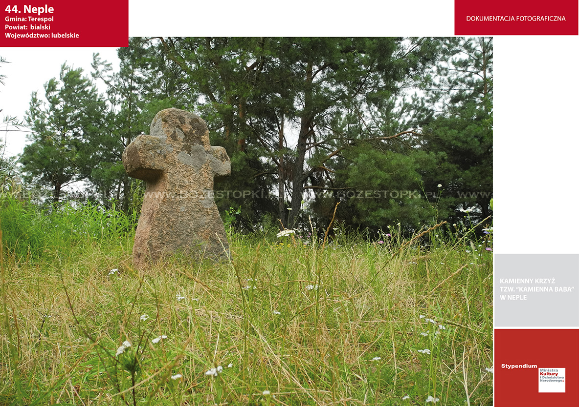
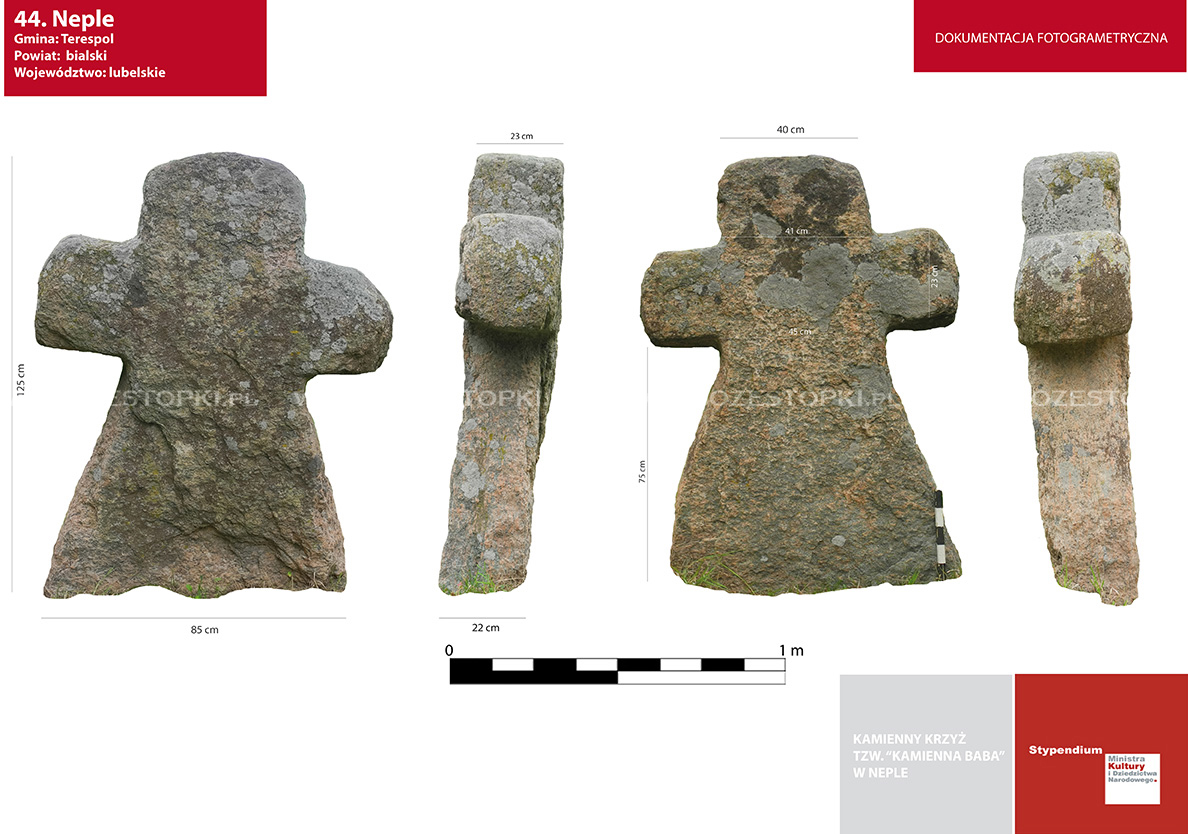
A stone cross made of gray granite, standing on a hill called "Stone Baba" (the monument is probably a late medieval or modern grave cross).
According to local legend, she is a girl enchanted into stone by her mother:
"In the village there lived a beautiful girl who very much wanted to marry one bachelor from the village, but her parents did not approve of her choice. Mino the young couple decided to get married, the girl dressed festively for the wedding and set off to the church alone. Her mother shouted for her that she had better turn into stone rather than get married against her will. The curse came true, on the way to the church the girl petrified and turned into a boulder." (according to one informant in the village of Neple)